Translate

8/05/19

Micro CHP


Solar Cogeneration and Net Metering Systems
A cogeneration plant often referred to as a combined heat and power plant is tasked with producing electricity and thermal energy in the form of heat or steam, or useful mechanical work, such as shaft power, from the same fuel source. Micro-CHP engine systems are currently based on several different technologies: Internal combustion engines, Stirling engines, Fuel cell, Microturbines, Steam engine/Steam motor using either water or organic chemicals such as refrigerants.
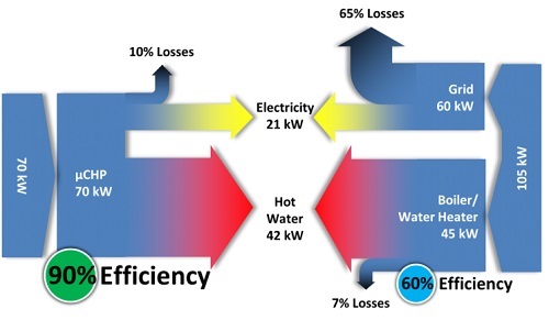
Micro combined heat and power or mCHP applies to single or multi-family homes or small office buildings in the range of up to 50 kW. Local generation has the potential for a higher efficiency than traditional grid-level generators since it lacks the 8-10% energy losses from transporting electricity over long distances as well as 10–15% energy losses from heat transfer in district heating networks due to the difference between the thermal energy carrier - hot water - and the colder external environment.

Most Systems use natural gas as the primary energy source and emit carbon dioxide. A micro-CHP system usually contains a small fuel cell or a heat engine as a prime mover used to rotate a generator which provides electric power, while simultaneously utilizing the waste heat from the prime mover for a building's heating, ventilation, and air conditioning. A micro-CHP generator delivers electricity as the by-product or may generate electricity with heat as the by-product. 
Micro-CHP systems have been facilitated by recent technological developments of small heat engines
Type
2008 Status
2012
2015
2020
Electrical efficiency at rated power
34%
40%
42.5%
45%
CHP energy efficiency
80%
85%
87.5%
90%
Factory cost
$750/kW
$650/kW
$550/kW
$450/kW
Transient response (10%–90% rated power)
5 min
4 min
3 min
2 min
Start-up time from 20 °C ambient temperature
60 min
45 min
30 min
20 min
Degradation with cycling
< 2%/1000 h
0.7%/1000 h
0.5%/1000 h
0.3%/1000 h
Operating lifetime
6,000 h
30,000 h
40,000 h
60,000 h
System availability
97%
97.5%
98%
99%

CPVT Concentrated photovoltaics and thermal also called CHAPS combined heat and power solar, is a cogeneration technology used in concentrated photovoltaics that produce electricity and heat in the same module. The heat may be employed in district and water heating, air conditioning, process heat or desalination.
Net metering micro-CHP systems achieve much of their savings by the value of electrical energy which is replaced by auto produced electricity. A generate-and-resell model supports this as home-generated power exceeding the in-home needs is sold back to the electrical utility. This system is efficient because the energy used is distributed and used instantaneously over the electric grid.
Tell us about Your Energy Savings Plan

Washington County Maryland


Arts Entertainment and a Civil War Legacy
Hagerstown located in Western Maryland it features a distinct topography, formed by stone ridges running from northeast to southwest through the center of town defining its neighborhoods. These ridges consist of upper Stonehenge limestone; the older buildings were built from this stone which is easily quarried and dressed onsite. Several of Hagerstown’s churches are constructed of Stonehenge limestone; brick and concrete eventually displaced this native stone.
Hub City German immigrant Jonathan Hager built the first house here in 1739 and began laying out the town in 1762. Hager House still stands as a carefully preserved museum, giving visitors a window to the 18th century. The National Road brought growth and the railroads intersecting here gave it its nickname, “Hub City.” The largest Civil War cavalry battle fought in an urban setting happened here.
City Park offers 50 acres of beautiful outdoor space and Hagerstown City Farmers Market sells crafts and baked goods as well as homegrown produce from area farmers.
The Arts & Entertainment District is home to the Maryland Theatre’s year-round performances and events, including Maryland Symphony Orchestra concerts. Hagerstown is also home to the Western Maryland Blues Fest. The Washington County Museum of Fine Arts is in scenic City Park.
The Hagerstown Cultural Trail links the Arts District with City Park and Fine Arts Museum
A Transit Center, Hagerstown is the chief commercial and industrial hub for a Tri-State Area that includes much of Western Maryland as well as portions of South-Central Pennsylvania and Eastern West Virginia.
Washington County is home to many quaint towns, including:
Boonsboro founded by relatives of Daniel Boone and situated along the main road to Hagerstown and Frederick. Historic markers explain the National Road, Civil War battles, and quaint shops line Main Street including author Nora Roberts' bookstore and bed and breakfast.
Clear Spring is located 12 miles west of Hagerstown. The historic National Pike which once linked the port of Baltimore to the western frontier of Ohio, runs through the center of town. Area attractions include Knob Hall Winery, Whitetail Mountain Resort, the C&O Canal and Fort Frederick State Park.
Explore the C&O Canal Towpath and the Western Maryland Rail Trail
Civil War Legacy Sharpsburg was the place where two massive armies clashed, leaving 23,110 dead, wounded, or missing. Every building overflowed with the wounded and dying. After the Civil War, its population declined; today, it has fewer than 700 residents, many direct descendants of families here during the Civil War. The Antietam National Battlefield and the Antietam National Cemetery are part of Sharpsburg, and nearby museums such as the Pry House Field Hospital Museum attract international symposiums. Smithsburg played a role in the Civil War, when residents helped care for wounded soldiers after the battles of Gettysburg, Monterey, South Mountain, and Antietam.
Williamsport is located at the confluence of Conococheague Creek and the Potomac River. When the C&O Canal opened in 1834, it evolved into a thriving waterfront town. It was also once considered a potential site for the United States’ capital.
Williamsport is the Finish Line for the JFK 50 Mile the Oldest Ultra-Marathon in North America

South Italy Castles and Coastal Towers


The History of Coastal Towers goes hand in hand the political and military evolution of the Kingdom of Naples. Fortifications were built in Southern Italy over and eight-hundred-year period from the 9th to the 17th centuries. The original towers were cylindrical in shape, tall and with small windows. Their main function was to sound the alarm when pirate ships were sighted through the lightning of fires, allowing the local population to find shelter into the hills and grottoes inland from the coast.
Increased Raids during the 16th Century led to Development of More Complex Coastal Defenses
Naples Viceroy Don Pedro of Toledo ordered the construction of massive, square-shaped towers with thicker external walls. The transition from circular-shaped towers to square-shaped ones was spurred by the introduction of artillery requiring fortifications whose functions now included sighting, signaling, shelter as well as the use of offensive weapons that could hit a ship approaching the coast.
Communications were carried out through a series of visual signals - smoke in the daytime, fires by night as well as acoustic signals such as bells, or shots from a cannon or arquebus, a precursor of the rifle. When a pirate ship was sighted from one tower, one of these signals would be used to warn the people of the area to prepare to fight or flee. The signal would be passed from tower to tower, up and down the coast, passing the word quickly and effectively. The ground level floor had no windows and was set directly above a large cistern to guarantee a constant water supply. This space was used to store food and munitions and also contained a millstone for grinding wheat, making the tower self-sufficient.
Saracen Towers can be viewed along the Southern Italian coastline from Gaeta to the Sorrento peninsula, the Amalfi and Cilento coasts. There are over 350 towers, including 30 along the coastal strip from Vietri sul Mare to Positano. Some have been restored and incorporated into modern buildings in small harbors such as San Marco, Pisciotta and Marina di Camerota. Further south, around Cape Infreschi just before reaching Scario, there are cliffs along the coast unreachable by road; here the original coastal towers stand just a few hundred yards apart.
The Term Saracen has shifted over time. Ptolemy's Geography from the second century mentions Sarakene as a region in the northern Sinai Peninsula and refers to a people called the Sarakenoi. For Italians during the middle ages it meant Muslim invader, from the Arabs who rode the initial wave of Islamic expansion into Spain and Sicily in the 8th and 9thcenturies to the Ottoman Turks who took Constantinople in the 15th century.
Coastal Watchtowers were also as a point of reference for friendly ships. The towers were generally manned by a military team of four guards and a horseman, who often remained outside the tower ready to ride into town to carry a warning as soon as possible.


The Wines of Campania


Romans Greeks Sannio Irpinia DOCG DOC IGT Aglianico Greco Falanghina Falerno Fiano
The Romans favored the vineyards along the coast north of Naples where Falernian, the most treasured wine of the empire, was grown. They also praised the wines of volcanic Vesuvius and the wooded hills of Avellino.
The Greeks introduced Vines Which Still Stand Out Today as Aglianico Greco and Falanghina
In Campania, wine producers make the most of native vines, including an honor roll of archaeological varieties which dates back to antiquity. The noblest of red varieties is Aglianico, which makes the red Taurasi, as well as the red Falerno del Massico.

Taurasi is Known as the Barolo of the South
Greco is the base of Fiano di Avellino and Greco di Tufo. Falanghina is the base of the white version of Falernian. Campania’s DOC zones also include the islands of Capri and Ischia, as well as the recently revived Penisola Sorrentina and Costa d’Amalfi, produced in terraced seaside vineyards from Sorrento to Amalfi.
Campania Appellations: DOCG Fiano di Avellino, Greco di Tufo, Taurasi DOC Aglianico del Taburno, Aversa, Campi Flegrei, Capri, Castel San Lorenzo, Cilento, Costa d’Amalfi, Falerno del Massico, Galluccio, Guardiolo, Irpinia, Ischia, Penisola Sorrentina, Sannio, Sant’Agata dei Goti, Solopaca, Taburno, VesuvioIGT Beneventano, Campania, Colli di Salerno, Dugenta, Epomeo, Irpinia, Paestum, Pompeiano, Roccamonfina, Terra del Volturno.
Irpinia the rail line linking Avellino and Rocchetta Sant’Antonio was known as the Wine Line; such was the importance of wine productionin this area. Avellino County features Greco di Tufo, Taurasi and Fiano.
The Fiano di Avellino takes its name from the variety that the Latins called Vitis Apiana because the vine’s grapes were so sweet that they proved irresistible to bees (api). Highly appreciated in the Middle Ages; an order for three salme – a measure – of Fiano is entered in the register of Holy Roman Emperor Frederick II and Charles d’Anjou had 16,000 Fiano vines planted in the royal vineyards.
Dry Fiano Features Scents of Toasted Hazelnuts
Greco di Tufo is the oldest variety of the Avellino area. It was imported from the Greek region of Thessaly asconfirmed by the discovery of a fresco in Pompeii. The Greco variety was originally cultivated on the slopes of Vesuvius, where it was given the name Lacryma Christi. It was later planted in the province of Avellino, where it was given the denomination Greco di Tufo.
Taurasi is the center of the production of the red wine of the same name; is a wine of great body and structure, dry and austere, with an aromatic vein. The wine must be aged for three years, of which one in chestnut or oak casks. In the three succeeding years, the wine can be tasted in the fullness of its quality and is particularly good as an accompaniment to roasted red meats.
Aglianico was Introduced at the Founding of Cumae the Grapes are Round and Blue in Color
Sannio is a hilly area where the best land has always been used for growing grapevines. The climatic conditions here are ideal for the ripening of grapes. Pliny, Columella, Cato and Horace have written on the excellence of the wines produced from the historical grapevines of Samnium – Aglianico, Coda di Volpe, Falanghina, Fiano, Greco, Moscato, Piedirosso, and Sciascinoso.
Aglianico is a red-grape variety that is widely diffused in Basilicata and in Campania in the provinces of Avellino and Benevento, where it is known by the names of Gnanico, Agliatica, Ellenico, Ellanica and Uva Nera. The production zone of the Aglianico del Taburno in the province of Benevento is a district of high hills that is subject to particularly severe winters.
The best way to travel is in the company of people who live and work in the places you visit

8/01/19

Havre de Grace Maryland


rivers canals an historic district museums local artisans and the underground railroad
Havre de Grace is at the mouth of the Susquehanna River and the head of Chesapeake Bay. It is named after the French port city of Le Havre - the Harbor of Grace. During the Revolutionary War, the small hamlet known as Harmer's Town was visited by General Lafayette who commented that the area reminded him of the French seaport.
George Washington stayed overnight in the town in 1789 on the journey to New York City for his first inauguration. During the First Congress in 1789, Havre de Grace missed by only one vote being named the capital of the fledgling United States.
Early Industry in Havre de Grace included oyster and crab harvesting as well as fruit orchards. Products were shipped to markets along the East Coast and upriver.  Havre de Grace became known for duck hunting, and was a seasonal destination for hunters who hired local guides to escort them hunting on the river and along the bay.
Local Artisans Made High Quality Decoys now on Display in the City’s Decoy Museum

The Southern Terminus of the Susquehanna and Tidewater Canal bypassed difficult navigational areas of the lower Susquehanna River between Havre de Grace and Wrightsville, Pennsylvania, where it connected to the Pennsylvania Canal. It was built between 1836–1840. The Lock Keeper's house and remnants of the canal exist today as a museum.


The Underground Railroad Havre de Grace was a primary town on the Eastern Route as slaves crossed the Susquehanna to havens in Pennsylvania, on the way to Philadelphia and New York. By the 1860s, a large population of free African Americans had settled in the town, supporting independent artisans, as well as jobs associated with shipping on the river, canal and the railroads.
The Seneca Cannery, currently an antique shop, is a very good example of a late 19th century brick industrial building with its classical facade and massive stone buttresses on the rear. Many patents followed the opening of the S. J. Seneca Cannery: 1901, The Baling-press; 1905, The Cooker and the Tomato Scalder; 1917, Improved Tomato Scalder and the Can-opener; 1918, Tomato Peeling Machine.
The Central Business District was added to the National Register of Historic Places as the Havre de Grace Historic District, which recognizes its architecture and historic fabric. A variety of museums help explain and interpret the city's rich maritime past and present: the Decoy Museum, the Havre de Grace Maritime Museum, Concord Point Lighthouse, the Lockhouse Museum, the Black Eyed Susan paddle steamer. Havre de Grace also claims a renovated seaplane port.
The Environment the town is located on a freshwater wetland, tidal cove, and small forested area teeming with species of flora and fauna; the backdrop for generations of inhabitants, from the earliest Native tribes to the first European colonists in the 1600s, to today's thriving 21st century community.
The Maritime Museum is a 10,000 square foot, three-story modern building adjacent to Concord Point Heritage Corridor, Havre de Grace's historic district spanning five waterfront acres and a designated attraction on the National Park Service's John Smith and Star Spangled Banner Trails.


5/16/19

Destination Vermont


Agriculture and Industry Heritage Museums Historic Sites Small Towns and Downtowns
Agriculture and Food Heritage experience Vermont’s thriving food and arts scene, local cuisine from artisan chefs, creative food companies, and passionate farmers thriving alongside artists sharing their arts and crafts.

Museums tell the story of Vermont’s heritage, arts and crafts. Early Vermonters were hardworking and industrious; museums of agriculture and industry tell the stories of how natural resources were employed to help provide for families and build Vermont: the American Precision Museum in Windsor, the Billings Farm in Woodstock, the New England Maple in Pittsford, the Vermont Granite in Barre and the Vermont Marble Museum in Proctor.
Learn the Stories of Shipwrecks the Lake Champlain Maritime Museum in Vergennes
Downtowns and Small Towns Vermont's thriving downtowns are where visitors and residents find the distinctive local businesses, historic buildings, and rich cultural and social activities that form Vermont's special sense of community. These authentic and attractive downtowns and villages are recognized as a key part of the state’s allure.
Vermont Downtowns are a Centerpiece of Community Life
The Downtown Program, established in 1994, is a revitalization effort that builds on each community’s history; these local efforts have demonstrated how revitalization encourages the local economy and cultural institutions, while supporting growth in a way that minimizes environmental impacts.
Waterbury is a vibrant community in the Green Mountains, encompassing Waterbury Village, Colbyville and Waterbury Center.  A 20-minute drive from Montpelier, 30 minutes from Burlington, and midway between the resort areas of Stowe and the Mad River Valley, Waterbury sits at the intersection of three of Vermont’s most heavily traveled and scenic roads. Downtown is home to a colorful mix of residential neighborhoods, civic and cultural facilities, independent small businesses and the Ben & Jerry Factory. 
Newport lies on the southern shore of Lake Memphremagog just a few miles south of the Quebec border. Visitors can pursue year-round outdoor adventures, including boating, swimming, hiking, biking, fishing, skiing, and snowmobiling.
Newport eateries source local foods and turn them into award winning dishes
Burlington and its walkable waterfront are home to a thriving arts scene, creative entrepreneurship, great shopping, three colleges and a university, and a full range of four-season outdoor pursuits. Fountains, a brick-paved pedestrian mall, and historic buildings ranging in style from Victorian to Art Deco and Streamline Modern provide the backdrop for the Church Street Marketplace. The nearby waterfront includes lakeside parks, ferry crossings, excursion boats, and a 12.5-mile walk and bike path that connects to the Lake Champlain Islands and its 200 miles of shorelines.
one of the best 100 small arts towns in America
Montpelier is the largest urban historic district in Vermont. Of the exquisite historic buildings, the crown jewel is the impeccably restored State House, one of the oldest and best preserved in the country. Three blocks away is the city’s bustling business district where independently owned shops offering books, recordings, clothing, fine crafts and pastries. 


 Your Destination Vermont Travel Plan
tema@arezza.net   skype arezza1   https://arezza.org

5/08/19

A Tuscan Countryside Medieval Castle and Arms Museum


Monteriggioni stands on a hilltop surrounded by olive trees and vines. Its castle dates-back to the early 13th century; it was built by the Republic of Siena as a defensive outpost against Florence. The Medieval Town maintains its original architectural features and is unique among Tuscany’s borghi. The stone outer wall is 570 meters long and features 14 rectangular towers; they made a great impression on Dante Alighieri who defined them as giants in hell. Walking on top of the walls provides a spectacular view of the countryside, the Chianti region and the Elsa Valley.
The Arms Museum houses faithful reproductions of medieval and renaissance weapons and armor as well as siege machines and techniques. Each room is devoted to a specific moment in Monteriggioni history. Visitors can wear the armor and handle the weapons.
The Church is located on the main square and is the best-preserved property in the borgo. Also built in the 13th century, it consists of a single interior space with a rectangular end. Its elegant façade displays a doorway with a stone arch topped by a round window while the renovated interior has plastered walls and domed vaults; the bell dates to 1299. The church is also home to a 17th century painting of the Madonna and Rosary which the town celebrates every year in October.
Porta Franca is the main entrance to the borgo; it stands below a tower with a pointed arch and facing towards Rome. In the past it likely had a drawbridge over a moat. To the left of the arch is an inscription commemorating the founding of Monteriggioni in the 1220s, while a plaque on the right celebrates the new Italian state in 1860.
Porta di Ponente is the gateway facing Florence. Some battlements incorporated in the walling above indicate that the defensive wall was probably lower. Similar battlements in the facing of the walls on the east side. To the right of the entrance, which used to have an outer protective wall, a plaque quotes lines from Dante that mention Monteriggioni.
In Medieval Times, on the southwest side of the outer walls, there was a third gateway, later walled in; the upper part is still visible from the outer road. In the 16th century, the base of the outer walls was reinforced with an earth rampart in response to the introduction of new and more powerful firearms.


A Medieval Travel Experience in Tuscany