Translate

10/09/19

Chesapeake Bay and the Maryland Eastern Shore


history geology hydrology fishing and the environment
Chesapeake Bay is an estuary and the largest such body in the contiguous United States and is a very important feature for the ecology and economy of the Middle Atlantic Region. More than 150 major rivers and streams flow into the bay's 64,299-square-mile - 166,534 km2 covering parts of six states.
History in 1524, Italian explorer Giovanni da Verrazzano sailed past the Chesapeake, but did not enter the bay. Spanish explorers may have been the first Europeans to explore parts of the bay which they named Bay of the Mother of God. In the late 16th century the British founded a colony and Captain John Smith explored and mapped it between 1607 and 1609. The first designated all-water National Historic Trail was created in 2006 following Smith's historic 17th century voyage.

The Eastern Shore is home to crabbers, oystermen, gentlemen-farmers and sharecroppers, boat builders and antiques dealers. Activities include fishing, crabbing, swimming, boating, kayaking and sailing. 

Geology and Hydrology the bay was formed starting about 10,000 years ago when rising sea levels at the end of the last ice age flooded the Susquehanna River valley.  Much of the bay is shallow; it is approximately 200 miles - 320 km - long and 2.8 miles  - 4.5 km - wide at its narrowest and 30 miles - 48 km - at its widest point. Average depth is 21 feet - 6.4 m. Because the bay is an estuary, it has fresh water, salt water and brackish water.


Fishing once employed up to nine thousand watermen and their skipjacks, the only remaining sailing workboats in US waters, engaged in the seafood production of blue crabs, clams and oysters. Now, runoffs from farms and urban areas, over-harvesting and foreign species invasions have made the bay less productive. Oyster farming helps maintain the estuary's productivity and is a natural effort for filtering impurities and reduce the amount of nitrogen compounds entering Chesapeake Bay.


Environment in the 1970s, Chesapeake Bay was discovered to contain marine dead zones - waters depleted of oxygen and unable to support life – that weaken the base of the estuary and its food source. The runoff and pollution have many components that help contribute to the algal bloom which is mainly fed by phosphorus and nitrogen. This algae prevents sunlight from reaching the bottom of the bay while alive and deoxygenates the bay's water when it dies and rots. Also, the overharvesting of oysters has made it difficult for them to reproduce, which requires close proximity to one another. The depletion of oysters has had a particularly harmful effect on the quality of the bay as they serve as natural water filters, and their decline has further reduced the water quality of the bay.

10/04/19

Art Cities and Food Traditions in Puglia Italy


Apulia (Puglia) is located in southern Italy; it borders the Adriatic Sea in the east, the Ionian Sea to the southeast, and the Strait of Otranto and Gulf of Taranto in the south. Its southernmost portion, the Salento peninsula, forms a high heel on the boot of Italy. 

Art Cities
Lecce is known as the Baroque city and the Florence of the south because of its magnificent architecture constructed with the famed Lecce Stone. Itinerary: Porta Napoli; Piazza del Duomo Cathedral and Belfry, Episcopio and Seminary Palace; Sant’Irene Church; Piazza Sant’Oronzo and Amphitheater, Sedile, Chiesa di San Marco Church and Sant’Oronzo Column; Santa Croce Basilica; Celestini Convent.
 
Barletta once a fortress, the Barletta’s castle was once surrounded by the sea. The historic center visit includes: Santa Maria Maggiore Cathedral; Eraclio’s Colossus, Santo Sepolcro Basilica and large bronze statue; Marra Palace, the Orsini family residence; Porta Marina, a unique example of a city wall gate; Cantina della disfida, the legendary battle between Italian soldiers of fortune led by Ettore Fieramosca and the French Army.


Trani the castle is the best preserved and most important among those erected by Frederic II. The Cathedral of San Nicola, the queen of cathedrals in Apulia, was built along the seashore, as was the castle, with a Latin cross layout, is divided into three naves and twin columns, a unique feature among the region’s Romanesque churches. The historic center itinerary included a visit to the Jewish quarter and two ancient synagogues.

Lucera this ancient town boasts one of the largest historic centers in Italy which holds the Cathedral of the Assumption, built on the foundations of an ancient mosque. Trani’s highest hill contains the Roman acropolis and a Swabian-Angevin fortress; the latter is a major archeological that features neolithic huts, Roman ruins and from a Frederic II palace as well as the remnants of the medieval era Church of St Francis. Finally, the Roman Amphitheater, Apulia’s most important Roman era structure.

Bari the most important city on the Adriatic Sea presents a medieval historic center that contains the city’s most important monuments, folkloristic features and the imposing San Nicola Cathedral.


Altamura is characterized by a series of cloisters, including a Jewish one. Its religious history is quite unique in that for seven centuries, beginning with the Frederic II era, Altamura’s bishops were appointed  by the prevailing secular powers; the Lateran Pact of 1929, governing relations between the Italian State and the Vatican, returned this specific power to the papacy. A major attraction is a visit to 15th Century stone oven that produces the classic Altamura bread and the Apulian focaccia.


Taranto can be defined as 2700 years of history on an island-historic center between two bodies of water, the Mar Piccolo and the Mar Grande. This unique setting contains a Greek acropolis, Roman and Renaissance architecture and baroque residences. Among Taranto’s principal mounuments: the Aragonese Castle, the Doric Temple’s column, S. Cataldo Cathedral and the Convent of San Domenico.

UNESCO Sites

Castel Del Monte Frederic II’s octagonal structure is unique in form and function. The form presents architectural considerations as well as still mostly unexplained symbolisms. An exterior and interior tour focus on the times when the castle was built as well the history of the emperor who commissioned it.


Alberobello the Trulli trace their origin to a 15th Century edict by the Kingdom of Naples requiring tribute for every new settlement. Alberobello’s owners, the Counts of Conversano, instructed their subject to build temporary structures, not subject to any form of taxation. Furthermore, these stone structures required self-supporting domes as rooftops, made of superimposed circles of stones; hence the peculiar cusp shape.

Monte Sant’Angelo is located in Apulia’s Gargano promontory. The medieval quarter is characterized by terraced houses, traces of its Longobard period and the Sanctuary with the cult of the Archangel Michael who, according to tradition, appeared in a grotto. Also, the Norman Castle, the historic center and St’ Michael’s Basilica.
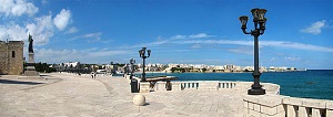
Otranto situated on Salento’s Adriatic Coast, is Italy’s easternmost town. With Messapi, Roman, Byzantine and Aragonese roots, it developed around its imposing castle and Norman Cathedral. Additional points of interest: the defensive walls and gate, the historic center, s. Peter’s Church, the Cathedral with Martyrs’ Chapel, vault and floor mosaics.
Archeological Museums

Egnazia Museum and Park is located between an olive grove and the sea. Partially excavated, it contains mostly Roman era finds: Via Traiana, Civil Basilica, oriental divinity shrine, an amphitheater and a colonnaded square. The museum is divided into 7 areas that illustrate the town’s history from bronze era huts to the medieval period that ended in the 13th Century, when Egnazia was abandoned by its population.


The Bisceglie Dolmen is Italy’s most recognized prehistoric monument. It consists of a two meter high quadrangular cell made of three vertical stone slabs that hold a larger fourth slab acting as a roof. The left slab has two openings, probably for the flow the sacrificial victims’ blood. The cell has an external corridor – dromos - with small stone slabs. Among the cell’s finds: charred animal bones, human skeletons, various plates and utensils.

Taranto Archeological Museum the MARTA collections lead to a complete picture of the city’s ancient history. Emphasis is on Greek Taranto’s funeral culture and the finds uncovered in the city’s necropolis and Greek society: theater, games, symposia and artistic expressions. Also, a review of the Roman era as illustrated by the museum’s mosaic floors.

10/03/19

A Journey into the Venetian Past


Venice Isles Food Wine and History
A Walking Itinerary of the most famous sights, including St Mark’s Square and Basilica, the Rialto Bridge, the Doge Palace and the Ponte dei Sospiri.
Venetian Cooking Class our expert cook will teach you how to prepare the local dishes and entertain you by analyzing the intriguing fragrances, the exotic origins of some ingredients, the cooking processes as well as answer your questions about the products being used. Classes are held in a Palazzo apartment in Venice or in a Liberty Villa at the Lido beach, a fascinating bathing resort with tall trees and gardens traversed by several canals. 
Reduce Transit Times and Travel Cost on Your Next Trip
Venice wine tasting in a typical bar or in an ancient Palazzo on the Grand Canal, held by a professional Sommelier presenting various wines, accompanied by intriguing stories about local history, as you experience the lifestyle of a Venetian aristocrat.
Escape crowded Venice for a day and unwind on a trip to the islands of Murano and Burano for a rare glimpse into what Venice used to be; a community of traditional artisans where skills have been passed down from one generation to the next for centuries.
Murano’s Ancient Art of Glassblowing
Burano is famous for its lace making and for the colorful houses crammed along its canals, so painted by fishermen who wanted to spot their homes from a distance. Visit a small building where women sit stitching lace the old-fashioned way, just as their mothers and grandmothers did. Also, take time to admire the delicate lace in the museum, shop or wind your way along the kaleidoscopic streets.
Wine Tasting enter the fascinating Venetian back country and discover the Regional Park of the Euganean Hills, a natural area dotted with small villages, vineyards and typical osterie. Visit a family-owned wine cellar and taste its sparkling wines and the local genuine products. Experience the amazing ancient village of the Poet Petrarca, unchanged since the 14th century.
A Journey into the Venetian Past

Milan Monza and Lake Como


Water Food Fashion and Design
Unlike most European and world leading cities, Milan was not settled on a river or by the sea, but in the middle of the Po River Valley. Hence, Milan’s is a history about water and how water was brought to the city. The concentric layout of the city center has been influenced by the Navigli, an ancient system of navigable and interconnected canals, now mostly covered.
Water History and Leonardo Da Vinci
A Source of energy for transportation and as a defense system throughout the centuries. Leonardo Da Vinci spent his most productive years in Milan, and his activity as an engineer crossed with the water history of the city; marks of his activity are still visible after hundreds of years. Water, sustainability and Leonardo are the threads that unify the different epochs in the city’s history and this part of Italy.

Traditions and Innovations in Energy and Water

Classical Milan the old Roman city of Mediolanum, and the more hidden parts of Milan, will connect the visitor with old artisan shops, the new Museum of Cultures, Villa Necchi Campiglio and the Last Supper.
Shopping and Design Milan is a global capital in industrial design, fashion and architecture. It is also a mecca for food lovers. As the commercial capital of Italy and one of Europe's most dynamic cities, it accounts for the lion’s share of the fashion trade, with some of the most renowned fashion houses headquartered here. Its upscale fashion district- il quadrilatero della moda - and La Galleria, the world’s first shopping mall, offer the best shopping opportunities anywhere.

Reduce Transit Times and Travel Costs on Your Next Trip
The Royal Villa in Monza has its own history dating back to the middle ages with a Royal Villa and the surrounding Monza Park. Recently restored the villa rivals in size and quality Versailles and Caserta’s Royal Palace. Behind the Royal Villa, Monza Park is the largest walled park in Europe. You may be already familiar with it as the racetrack where the Monza Formula 1 Grand Prix takes place every September.
Lake Como Bellagio is a cozy old village where the two branches of the lake converge in a narrow Canyon and where the water is still feeding an old-fashioned power plant. Isola Comacina is an old settlement with ruins dating back from the middle ages, and a terrific view of the Lake. The road back to Milan is via the Strada Regina - Queen’s Road - along the lakeshore and an opportunity to look at some gorgeous villas, including George Clooney’s residence.


Itinerari Culturali e Iniziative Ambientali


Beni Culturali e Musei Locali danno significato e scopo agli oggetti esposti in musei e gallerie d'arte in quanto rivelano il patrimonio storico earcheologico di una comunità, influenzano la conservazione e la riscoperta del patrimonio culturale attraverso arte, storia, archeologia, letteratura e architettura, preservando la biodiversità e riscoprendo le culture associate con le comunità agricolecostiere e fluviali.

Cucina Locale Cantine Vinicole e Birrifici Ci sono diversi esempi affascinanti attraverso l’ America di una rinascita dell’ agricoltura e di una sempre crescente domanda per prodotti alimentari, vini e birre locali, di qualità e sostenibiliin comunità urbane e suburbanealimentata in parte da sviluppo economico nei centri storici e quartieri residenziali. Questoa sua voltaha generato una domanda per servizi di vita notturna e nei week-end per i per i cittadini locali ed i visitatoriEsperienze e atmosfere locali uniche nelle comunità americane dove molte attrazioni sono anche storiche esostenibili.
Un programma di sette notti e otto giorni per famiglie, scuole e gruppi tematici
Comunità e Iniziative nei Trasporti Pubblici Locali Negli ultimi anniefficienti e convenienti forme di trasporto pubblico - autobus per trasporto rapido, metropolitane, servizi ferroviari elevati, tram e altri - per il servizio urbano, suburbano e interurbano sono stati discussistudiati e in alcuni casi attuati. I nostri itinerari includono le principali città degli Stati Uniti con servizi pendolari e regionali così come le comunità che stanno implementando nuovi programmi di servizio pubblicoUn'occasione per incontrare pianificatori locali e dirigenti nonche’ viaggiare in modo efficiente, sicuro e conveniente durante la tua visita negli Stati Uniti.
Come Ridurre Tempi di Transito e Costi per il Tuo Prossimo Viaggio
Gestione delle Risorse Idriche e dell'Ambiente visita e studia i programmi delle comunità che si trovano in prima linea nella gestione delle risorse idriche ed altre pratiche eco-sostenibili per lo sviluppo costiero, fluviale e del lungomare nei piccoli centri, le grandi città e lecomunità agricoleI funzionari locali e gli amministratori non profit dell’ambiente, tra gli altriillustreranno le loro politiche, i programmi e le migliori pratiche di gestione in sistemi efficienti delle acque reflue e dei bacini idricila Land Conservancy, certificazioni LEED, il riciclo, la raccolta dell'acqua piovana e l'energia.  

10/01/19

Willamette River Itinerary


The Willamette River accounts for 15 percent of the Columbia River's flow. Its main stem is 187 miles - 301 km - in northwestern Oregon as it flows northward between the Oregon coast and Cascade ranges. The Willamette Valley basin that contains two-thirds of Oregon's population and is one of the most fertile agricultural regions in North America, hence the destination of many 19thcentury pioneers traveling on the Oregon Trail. The river supports 60 fish species, including salmon and trout.
The Upper Tributaries of the Willamette originate in the mountains south and southeast of Eugene and meanders north to join the Columbia about 101 miles - 163 km - from the larger River's mouth on the Pacific Ocean. The channel is the main navigational channel for Portland's harbor and industrial areas.
The Willamette River has over 50 Bridges and Crossings
Watershed The Willamette River drains a region of 11,478 square miles - 29,730 km2 - 12 percent of the total area of Oregon. Watersheds bordering the Willamette basin include the Deschutes and Sandy Rivers. Sixty-four percent of the watershed is privately owned, while 36 percent is publicly owned. 


Your anchor locations when visiting the Willamette River:
Portland Oregon and Seattle

Recent History by the early 20th century, major river-control projects began to take place. Levees were constructed along the river in most urban areas, and Portland built concrete walls to protect its downtown sector. Decades later, many large dams were built on Cascade Range tributaries of the Willamette. The Army Corps of Engineers operates 13 such dams, which affect flows from about 40 percent of the basin. With development near the river came increased pollution. By the late 1930s, efforts to stem the pollution led to formation of a state sanitary board to oversee modest cleanup efforts. In the 1960s, Governor Tom McCall led a push for stronger pollution controls to enhance historical, natural, and recreational values along the river.

There are 20 Dams on the Willamette as well as a series of Levees Dikes and Channels

The Willamette Greenway program has created a system of parks, trails, and wildlife refuges along the river leading to the 1998 appellation of American Heritage River


Connect for a Willamette River Itinerary

American River and Northern California Vacation


The American River runs from the Sierra Nevada to the San Joaquin Valley, eventually emptying into San Francisco Bay and the Pacific Ocean.
History The Maidu peoples inhabited the American River for thousands of years before foreigners settled the region. They utilized the vast river resources for shelter, clothes, baskets, and other goods.
The California Gold Rush started in 1848 when gold was found on the American River. The South Fork in particular was a top destinations for early miners.
River Forks the American River is divided into the North, Middle, and South forks; the three forks originate in the Lake Tahoe area. All three forks are known for their verdant canyons, forested ridges, massive rock formations, trails, winter adventures, snowy peaks, fishing and white water rafting. Fish species that live within the American River include the Chinook salmon and Steelhead Trout. 

American River Parkway below Folsom Lake, the river passes through an urban area and riparian park containing fishing and family-oriented rafting, paved bicycling and multi-use trails. Also, Leidesdorff Ranch, a 35 thousand acre - 140 km2 - cattle and wheat agribusiness.


Your anchor locations when visiting Northern California include Lake Tahoe, Sacramento, Sonoma and San Mateo Counties near San Francisco Bay
Ecosystem the climate of the California American River is Mediterranean; rainy winters and very dry summers. The region is prone to seasonal drought conditions. Sacramento County is known for its cool winters, and hot summers, with low average precipitation. Much of the Central Valley was historically wetlands, which made the ground very fertile and attractive for agriculture. The American provides Sacramento County with its main source of drinking water and houses a multitude of plants and wildlife, creating an immensely bio diverse ecosystem.
The American River Conservancy works to conserve the wildlife, aquatic and terrestrial habitats and resources around the American River watershed. The land they protect helps the American River water quality by conserving and resorting wet meadows, wetlands, and riparian areas. It also preserves the cultural and historic values of the river systems and surrounding landscapes.


Recreation whitewater rafting; the South Fork has Class III rapids, the Middle Fork has Class IV rapids, and the North Fork has Class IV spring run-off rapids. All three rivers also feature Class II sections.