Translate

Showing posts with label medieval towns. Show all posts

5/31/18

Land Water and Countryside Landscapes in the Po River Valley


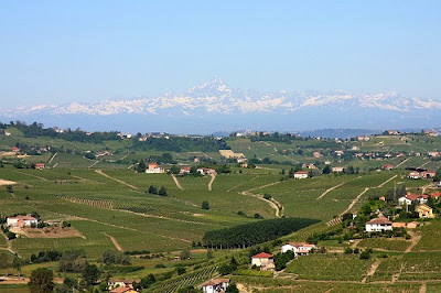
The Countryside around the Po River is now a huge expanse of fields, but once was a vast brughiera of swamps and forests. The village of Trino, at the crossroad between the old Roman military camps and the medieval towns of Milan, Turin, Vercelli and Asti, was a sacred forest called Lucedio (Lucus Dei), where the Cistercian monks settled in 1123 and built an abbey.
Near the Settlement, there is still a forest - Bosco delle Sorti della Partecipanza di Trino - managed with sustainable socio-criteria since 1202 and from 1991 a public park under FSC protection. Elsewhere in the Po Valley, the monks slowly reclaimed and brought the land under cultivation creating a new eco-environmental system, the Pianura Padana. 
In the Monferrato area by the Po river, the Pianura is an expanse of rice fields divided by canals and flooded in spring time, the so-called Terre d'Acqua, a water-land populated by many migrant animals - herons, storks, swallows. In between the fields there are many old and unique farmhouses, the so-called grange, built by the monks at a distance of half a day’s walk from each other. The reflections of sun rays and moon lights on the still water that covers the flat fields design a very particular landscape, which has been also captured by many artists. 

The Parco Fluviale del Po e dell’Orba is a park with conservation and environmental protection of the cultivated lands is assigned to the EcoMuseo delle Terre d’Acqua located in the Antica Riseria San Giovanni, founded in the 15th Century, which preserves the original plant and a 17th Century watermill. It also houses the Museo delle Macchine da Riso.
Palazzo Mossi (Mossi Palace) in Frassineto Po is where the Centro di Interpretazione del Paesaggio del Po shows environmental changes, the many historical, natural and geological events which over time have changed the landscape and the current configuration of the area.
Po River Tours a travel and education experience for families and groups to discover the history, traditions and cultures of this major waterway: Boat Tours; Culinary Experiences - wineries, breweries and local food; Walking, Biking, Canoeing Horseback Riding; Museums and Cultural Attractions; Accommodations and Transfers.


8/13/15

Central Istria


Central Istria
mythical landscapes medieval towns and a rich heritage

Any of the main roads from the eastern, western or southern Istrian coast will take you to Pazin in the center of the Istrian peninsula. The Kaštel fortification above the Pazin-Pisinočica River, a natural phenomenon and a beautiful example of the evolution of karst hydrography. Today it is home to the Ethnographic Museum of Istria and the Pazin City Museum.

To the north is Motovun, inhabited since prehistory and a picturesque medieval town with a rich cultural and historical heritage. It dominates over the Mirna River and the Motovun woods, famous for their truffles.

The town of Buzet is just upstream, on a hilltop in the middle of the Mirna River Valley and its Roman fortifications. The central square includes the parochial church of the Blessed Virgin Mary’s Assumption and the County Museum.

Roč is an active cultural center along with Hum - the smallest town in the world. Between the two small towns there is a unique memorial complex dedicated to the old Croatian Glagolitic alphabet and culture. Hiking trails take you from picturesque medieval architecture over the slopes to the Cicarija plateau and the largest Istrian mountain and nature park of nature; Učka is one of the last European localities where bird lovers will be rewarded with sights of the griffon vulture or the golden eagle. 

For Information and Reservations
                                                         Croatia@arezza.net 

Lupoglav, in northeastern Istria played an important part in area history; the creation of Pazin County resulted in a division between Austria and Venice with border disputes leading to numerous wars. Located at the crossroads of the main route from Trieste to Rijeka, it is an excellent base from which to visit Italy, Slovenia and Croatia: Trieste 64 km, Porec 53 km, Pula 65 km, Buzet 15 km, Motovun  22 km, Rijeka 35 km, Opatija 23 km, Ucka National Park 10 Km,  Plitvice National Park 200 km and Postojnska Jama  Grottoes in Slovenia 100 km. Points of Interest include:

Mahrenfels Castle, the residence of the local nobility, stood until the mid 17th century. Lupoglav was owned by the Bavarian Archdukes and was named Mahrenfels. A document dating back to 1112 first names Lupoglav with its current Croatian name.
  
Brigido Country Mansion, surrounded by a tall stone wall, the noble Brigido Family successfully introduced many agricultural innovations, particularly in livestock farming - the breeding of merino sheep, Egyptian sheep and Angora goat. A model estate of its time, many Istrian farmers sent their heirs to learn practical estate, agriculture and farm management.

In the south, you reach Žminj, a small town where old Istrian houses and holdings now serve as  farm houses; accommodations and  an opportunity to savor homemade Istrian cooking.

Further south is Svetvinčenat, the art center of southern Istria. It is placed on the karst plateau and surrounded by woods, pasture grounds and vineyards.
 
Connect with TEMA to Visit Central Istria
 

TEMA develops personalized travel itineraries based on client interests by leveraging an in-depth knowledge of your destination, superior client service in the planning stages and throughout the trip or event and logistics expertise to reduce accommodations and transport costs as well as transfer times.
Local Knowledge – Global Reach
tema@arezza.net |skype arezza1