Translate

10/01/19

Willamette River Itinerary


The Willamette River accounts for 15 percent of the Columbia River's flow. Its main stem is 187 miles - 301 km - in northwestern Oregon as it flows northward between the Oregon coast and Cascade ranges. The Willamette Valley basin that contains two-thirds of Oregon's population and is one of the most fertile agricultural regions in North America, hence the destination of many 19thcentury pioneers traveling on the Oregon Trail. The river supports 60 fish species, including salmon and trout.
The Upper Tributaries of the Willamette originate in the mountains south and southeast of Eugene and meanders north to join the Columbia about 101 miles - 163 km - from the larger River's mouth on the Pacific Ocean. The channel is the main navigational channel for Portland's harbor and industrial areas.
The Willamette River has over 50 Bridges and Crossings
Watershed The Willamette River drains a region of 11,478 square miles - 29,730 km2 - 12 percent of the total area of Oregon. Watersheds bordering the Willamette basin include the Deschutes and Sandy Rivers. Sixty-four percent of the watershed is privately owned, while 36 percent is publicly owned. 


Your anchor locations when visiting the Willamette River:
Portland Oregon and Seattle

Recent History by the early 20th century, major river-control projects began to take place. Levees were constructed along the river in most urban areas, and Portland built concrete walls to protect its downtown sector. Decades later, many large dams were built on Cascade Range tributaries of the Willamette. The Army Corps of Engineers operates 13 such dams, which affect flows from about 40 percent of the basin. With development near the river came increased pollution. By the late 1930s, efforts to stem the pollution led to formation of a state sanitary board to oversee modest cleanup efforts. In the 1960s, Governor Tom McCall led a push for stronger pollution controls to enhance historical, natural, and recreational values along the river.

There are 20 Dams on the Willamette as well as a series of Levees Dikes and Channels

The Willamette Greenway program has created a system of parks, trails, and wildlife refuges along the river leading to the 1998 appellation of American Heritage River


Connect for a Willamette River Itinerary

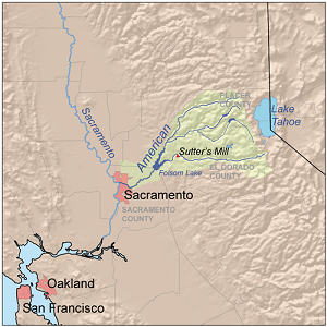
American River and Northern California Vacation


The American River runs from the Sierra Nevada to the San Joaquin Valley, eventually emptying into San Francisco Bay and the Pacific Ocean.
History The Maidu peoples inhabited the American River for thousands of years before foreigners settled the region. They utilized the vast river resources for shelter, clothes, baskets, and other goods.
The California Gold Rush started in 1848 when gold was found on the American River. The South Fork in particular was a top destinations for early miners.
River Forks the American River is divided into the North, Middle, and South forks; the three forks originate in the Lake Tahoe area. All three forks are known for their verdant canyons, forested ridges, massive rock formations, trails, winter adventures, snowy peaks, fishing and white water rafting. Fish species that live within the American River include the Chinook salmon and Steelhead Trout. 

American River Parkway below Folsom Lake, the river passes through an urban area and riparian park containing fishing and family-oriented rafting, paved bicycling and multi-use trails. Also, Leidesdorff Ranch, a 35 thousand acre - 140 km2 - cattle and wheat agribusiness.


Your anchor locations when visiting Northern California include Lake Tahoe, Sacramento, Sonoma and San Mateo Counties near San Francisco Bay
Ecosystem the climate of the California American River is Mediterranean; rainy winters and very dry summers. The region is prone to seasonal drought conditions. Sacramento County is known for its cool winters, and hot summers, with low average precipitation. Much of the Central Valley was historically wetlands, which made the ground very fertile and attractive for agriculture. The American provides Sacramento County with its main source of drinking water and houses a multitude of plants and wildlife, creating an immensely bio diverse ecosystem.
The American River Conservancy works to conserve the wildlife, aquatic and terrestrial habitats and resources around the American River watershed. The land they protect helps the American River water quality by conserving and resorting wet meadows, wetlands, and riparian areas. It also preserves the cultural and historic values of the river systems and surrounding landscapes.


Recreation whitewater rafting; the South Fork has Class III rapids, the Middle Fork has Class IV rapids, and the North Fork has Class IV spring run-off rapids. All three rivers also feature Class II sections.

8/25/19

Columbus Ohio


history transport hub industrial town breweries and historic villages named for explorer
Christopher Columbus it was founded in 1812 and became Ohio’s state capital in 1816. The city has a diverse economy based on education, government, insurance, banking, fashion, defense, aviation, food, clothes, logistics, steel, energy, medical research, health care, hospitality, retail, and technology.
Columbus is home to the Ohio State University
History the area including modern-day Columbus once comprised the Ohio Country under French control through the Viceroyalty of New France from 1663 until 1763 as Europeans engaged in the fur trade. In the 1740s, Pennsylvania traders overran the territory until the French regained control; the region routinely suffered turmoil, massacres and battles. Finally, the 1763 Treaty of Paris ceded the Ohio Country to the British.
Colonists from the East Coast moved in but encountered people of from several Indian nations, as well as European traders. The tribes resisted expansion by the fledgling United States, leading to years of bitter conflict. By 1797, a permanent settlement was founded on the west bank of the forks of the Scioto and Olentangy Rivers; the location was ideal for its proximity to navigable rivers.
Columbus became State Capital because of its Proximity to Major Transportation Routes
Transport Hub and a Major Industrial Town the National Road connected Columbus with Baltimore in 1831 in addition to the Ohio and Erie Canal facilitating the arrival of Irish and German immigrants by 1875 eight railroads served Columbus and its buggy factories steel producers and breweries. The American Federation of Labor was founded here in 1886 by Samuel Gompers, followed by the United Mine Workers in 1890.


Wooden Arches on High Street Provided Electricity for the New Streetcars
The Columbus Experiment was an internationally recognized environmental project in 1908, which involved construction of the first water plant in the world to apply filtration and softening, designed and invented by Clarence and Charles Hoover; an invention that reduced the incidence of typhus.
Port Columbus Airport was a Rail-to-Air Transcontinental System from the East to the West Coast
Neighborhoods and Villages modern interpretations of neighborhood borders vary significantly as historical neighborhoods, villages, towns and townships have been annexed and absorbed by the city.
The Italian Village is a mixed land use neighborhood that contains an array of residential, commercial, and industrial buildings. It is a designated historic district for its historical and cultural preservation. The building types and architecture reflect Italian influence. With its parks and preserved historic homes, Italian Village has the highest home value appreciation in Columbus. The neighboring Downtown District provides access to major employers, cultural and learning institutions, and entertainment venues.


The Victorian Village is in an older area with a fair number of established trees for an urban setting. Neil Avenue runs north/south and eventually crosses through the campus of The Ohio State University.

The Brewery District is located just south of the central business district with a history stretching nearly 200 years. The first brewery was opened by German immigrant Louis Hoster in 1836. At the height of its success, there were five breweries located in the area. Following Prohibition in 1920, the area become home to industry and warehouses. In recent years, redevelopment has taken place on a large scale, with restaurants and bars.


The German Village is a historic neighborhood settled German immigrants in the mid-19th century who constituted as much as a third of the population of the entire city. It has a commercial strip mainly centered along South Third Street, with mostly locally owned restaurants, as well as the tall-steepled St. Mary Catholic Church. The area is mostly a residential neighborhood of sturdy, red-brick homes with wrought iron fences along tree-lined, brick-paved streets.

Oxford Mississippi


Cultural Mecca of the South Small-Town Charm and Literary Destination
Oxford was founded in 1837, on land that had once belonged to the Chickasaw Indian Nation and named after Oxford, England. The Mississippi Legislature voted in 1841 to make Oxford the home of the state’s first University which opened its doors in 1848 to 80 students and has since become one of the nation’s finest public universities.
From the Civil War to Cultural Mecca in 1864 Union troops set fire to the Courthouse, most of the Square and many homes. During the Civil Rights movement, James Meredith entered the University of Mississippi as the first African American student. The city is now known as the home of Nobel Prize winning author William Faulkner and has been featured as a literary destination in publications such as Conde Nast Traveler, Southern Living and Garden and Gun.  Many writers have followed in Faulkner’s footsteps, making Oxford their home over the years adding to the literary reputation Oxford has become renowned for including: Larry Brown, Barry Hannah, Willie Morris, and John Grisham.
 
Geography the city is-located-in the North Central Hills region of Mississippi, known for its heavily forested hills and red clay. Downtown Oxford sits on one ridge and the University of Mississippi sits on another one, while the main commercial corridors on either side of the city sit in valleys.
The Square has remained the cultural and economic hub of the city and is home to a variety of shops, boutiques, the south’s oldest department store and a famous independent bookstore. Around the Historic Downtown Square there are restaurants ranging from down-home southern cooking to elegant haute cuisine.

The Circle Historic District is located at the center of the Ole Miss campus with eight academic buildings arranged on University Circle, including the Lyceum Building, Brevard Hall, the Croft Institute for International Studies, the Carrier, Shoemaker, Ventress, Bryant, and Peabody dormitory halls. The district also includes the flagpole, the Confederate Monument, and University Circle.

Paducah Kentucky


trade transportation arts and culture
Paducah is located at the confluence of the Ohio and Tennessee rivers, between St Louis and Nashville. The city is the hub of a micropolitan area comprising Kentucky and Illinois counties. First settled in 1821 and laid out by William Clark of the Lewis and Clark Expedition, it was named Padoucas, the word for Comanche from a Spanish transliteration.
Trade and Transportation
A River and Rail Economy was the key to Paducah’s development as a port, a red brick making factory, a foundry for making rail and locomotive components and dry dock facilities for steamboats and towboats comprised the town infrastructure. Thanks to its proximity to coal fields, Paducah was the home port for barge companies and an important railway hub connecting Chicago with the Gulf of Mexico.

The Paducah-McCraken County River Port Authority provides maritime services for the rural regions of Western Kentucky, Southern Illinois, Southeast Missouri, and Northwestern Tennessee. It specializes in bulk, agricultural and containerized cargoes. The agency specializes in bulk, agricultural, general and containerized cargoes, and operates a Foreign Trade Zone in the only Marine Highway Designation on the Ohio River and the only Marine Highway port on the river that is designated for container service.

Arts and Culture

The National Quilt Museum is a cultural destination that attracts quilters and art enthusiasts to the Paducah area. The museum features professional quilt and fiber art exhibits that are rotated throughout the year and is the largest single tourist attraction in the city.

Paducah is part of the UNESCO Creative Cities Network


The Paducah Wall to Wall program was begun by mural artists on the downtown flood wall in 1996; over 50 murals address subjects ranging from Native American history, river barges, steamboats and local African-American heritage.

Gillette Wyoming


energy capital of the nation

Gillette is centrally located in an area involved with the development of vast quantities of American coal, oil and gas Over the last decade, the population has increased 48 percent. Founded in 1891 with the coming of the Chicago, Burlington & Quincy Railroad, it was named for Edward Gillette, who worked as a surveyor for the company.  


The Rockpile Museum documents life in early Gillette. After the railroad moved to Sheridan, Gillette survived in order to serve the ranchers, cowboys, and homesteaders who were trying to make a life in the countryside surrounding the town. Cattlemen drove their herds into the livestock yards at Gillette for sale and transportation to the markets back east. Industrious citizens set up businesses to cater to these people and any who passed through. Livery barns, stables, and blacksmiths popped up to house travelers’ horses and haulers’ draft teams. Bars and brothels catered to those who pursued that lifestyle.


Tourism Gillette's inclusion on the Black and Yellow Trail in 1912, a highway extending from the Black Hills to Yellowstone, brought many different travelers and tourists into town via automobile resulting in construction of tourist camps, cottages, and motels along with cafes and eateries.

The Gillette Syndrome is named for the social disruptions that occur in towns experiencing rapid growth; during the 1960s, Gillette doubled its population from 3,580 to 7,194 resulting in increased crime, high costs of living and weakened social and community bonds.

Geography Gillette Wyoming is situated between the Bighorn Mountains and the Black Hills in the Powder River Basin. Devils Tower rises 1,267 feet - 386 m - above the Belle Fourche River; the summit is 5,112 feet - 1,559 m - above sea level.

Wabash Indiana


the Wabash and Erie Canal
The name Wabash derives from the Miami-Illinois phrase water over white stones; the Miami name reflected the clarity of the river whose bottom is limestone.  
The Wabash Post Office has been Operating since 1839
The first electrically lighted city in the world was inaugurated on March 31, 1880. The Wabash courthouse grounds were lighted with four 3,000-candle power lamps suspended from the top of the courthouse. Two telegraph wires ran from the lamps to the courthouse basement, where they were connected to a threshing machine to provide power.
Wabash is Home to Several Historic Districts
The Wabash and Erie Canal provided traders with access from the Great Lakes to the Ohio River; 460 miles long, it was the longest canal ever built in North America. The waterway was a combination of four canals: the Miami and Erie, the original Wabash and Erie from Junction to Terre Haute, Indiana, the Cross-Cut Canal from Terre Haute to Point Commerce, and the Central Canal from Worthington to Evansville. 
The Interpretive Center is an open-air village located on the banks of the canal in Delphi, Indiana. The interpretive center includes a model canal with a miniature reservoir, aqueduct, lock, and gristmill. The model canal boat General Grant shows the type of boats that carried freight on the canal during its final years of full-scale operation from the 1860s to 1874.

The Wabash & Erie Canal Association is dedicated to Indiana's Canal Heritage
Travel along the canal was accomplished by canal freight and passenger packets. The passenger packet consisted of a series of rooms and a main saloon where meals were taken. This room was converted into a men's dorm for sleeping. The women’s saloon was towards the back of the boat.
The Packets were Pulled by Horses and Oxen
The Route was from Toledo on Lake Erie to Fort Wayne. From here, it follows the historic Indian portage to the Wabash River, then heads downstream to Delphi and, using several other riverways, it reaches the Ohio River.